🌧️ STORM WATCH: RAIN AND LOCALLY HEAVY DOWNPOURS EXPECTED ACROSS NEW JERSEY SUNDAY ⚠️
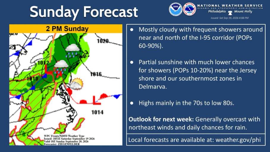
Periods of rain and heavy downpours are expected to cause localized flooding across New Jersey this Sunday. While weather conditions will briefly improve on Monday, more showers and gusty winds are forecast for the middle of the week.
Residents across the Garden State should prepare for a wet Sunday as periods of rain move across the region, with some locally heavy downpours possible.
A developing area of weak low pressure, combined with an approaching warm front, is expected to bring periods of rain throughout Sunday. 🌧️ Some locations could receive around an inch of rainfall, while heavier downpours may produce higher amounts in isolated areas.
⚠️ ISOLATED FLOODING POSSIBLE
The heaviest rain could cause localized flooding, particularly in areas prone to poor drainage. Drivers are urged to use caution and never attempt to drive through flooded roadways.
🚗🌊 Turn around, don't drown.
🌤️ WHAT'S AHEAD
Monday: Conditions are expected to improve, with a mix of sunshine and clouds as high pressure helps keep the unsettled weather to the south.
Tuesday: Shower chances increase again as another area of low pressure moves eastward off the Mid-Atlantic coast.
💨 Tuesday through Friday: Gusty winds are possible, particularly along the Jersey Shore, as strong high pressure remains to the north while an offshore storm lingers nearby.
🍂 By next weekend, conditions are expected to turn dry but cooler, with temperatures trending toward the feel of early autumn.
Average high temperatures for this time of year are generally in the mid-70s, while temperatures could fall into the 60s by Tuesday as autumn officially approaches.
📲 Stay with Garden State News Network for updates on this developing weather pattern and other New Jersey weather alerts.