🌊 NOR’EASTER THREAT GROWS AS COASTAL FLOODING AND STRONG WINDS TARGET NEW JERSEY
New Jersey is bracing for a coastal storm this weekend that could bring significant flooding, powerful winds, and dangerous surf. Local officials warn that full moon tides could worsen conditions, potentially leaving some low-lying roads impassable through Saturday afternoon.
NEW JERSEY — New Jersey’s coastline is bracing for worsening coastal flooding, dangerous surf and strong winds as a developing coastal storm moves offshore this weekend.
The National Weather Service in Mount Holly says the exact track of the storm remains uncertain, but coastal and bayside communities could experience repeated rounds of tidal flooding through the weekend.
🌕 FULL MOON COULD COMPLICATE FLOODING
The timing of the storm comes as elevated astronomical tides associated with the full moon add to the coastal flooding threat. Multiple high-tide cycles could bring additional water into vulnerable areas, particularly along the Atlantic coast, bays and tidal waterways.
Communities around Barnegat Bay, the Shrewsbury River, southern Raritan Bay and other back-bay locations could see persistent flooding.
⚠️ COASTAL FLOOD WARNINGS ARE ALREADY IN PLACE
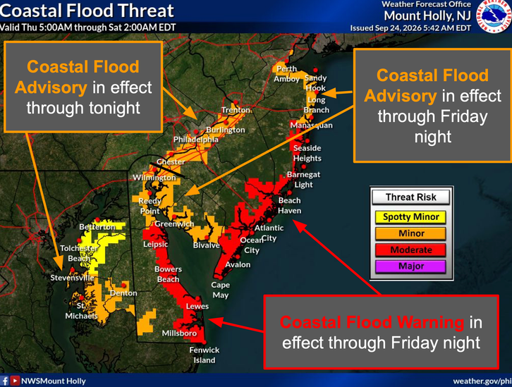
The National Weather Service currently has a Coastal Flood Warning covering parts of coastal New Jersey, including Ocean, Atlantic, Cape May and southeastern Burlington counties, through early Saturday. Forecasters warn that one to two feet of inundation above ground level could occur in low-lying areas, with widespread roadway flooding and some roads becoming impassable.
A Coastal Flood Advisory is also in effect for additional areas, including portions of Cumberland County.
🌬️ STRONG WINDS EXPECTED
The Jersey Shore is also facing increasingly strong winds.
The National Weather Service has a Wind Advisory through Friday evening for portions of the coast, with northeast winds of 25 to 35 mph and gusts up to 45 mph. A High Wind Watch is in effect from Friday evening through Saturday afternoon, when north winds of 30 to 40 mph with gusts potentially reaching 60 mph are possible in parts of the coastal region.
🌊 DANGEROUS SURF AND RIP CURRENTS
Beachgoers should also be aware of hazardous ocean conditions. A High Surf Advisory remains in effect along portions of the Jersey Shore, where breaking waves could reach approximately 9 feet in the surf zone. A high risk for dangerous rip currents is also expected through Saturday evening.
📍 WHAT TO EXPECT THIS WEEKEND
• Jersey Shore: Greatest concerns include coastal flooding, beach erosion, dangerous surf, rip currents and strong winds.
• Central Jersey: Coastal and bayside communities could experience repeated flooding during high tide, particularly around the Raritan Bay and Shrewsbury River.
• South Jersey: Barnegat Bay communities and other coastal areas could see significant tidal flooding, while strong winds and rough surf affect the coastline.
• North Jersey: Coastal areas could see flooding near tidal waterways, while inland communities face a lower but still possible risk of gusty winds and rain.
🌧️ The storm’s eventual track will determine how much rain and wind reaches inland New Jersey. A closer track to the coast could produce stronger winds, heavier rain and greater coastal impacts, while a farther offshore track would keep the strongest conditions closer to the ocean.
🚗 SAFETY REMINDER: Never drive through flooded roadways. Water depth can be difficult to judge, and road conditions can deteriorate quickly. Residents in flood-prone areas should monitor the latest forecasts and be prepared to move vehicles and property to higher ground if necessary.
The National Weather Service continues to emphasize uncertainty regarding the storm's track, so conditions and forecasts could change as the system develops.
📲 Garden State News Network will continue monitoring the storm and will provide updates as conditions develop across New Jersey.